 Skip to main content

George Huish, Product Manager at the UKHO, explores how spatial data can help unlock the potential of the blue economy.
Learn about Marine Spatial Data Infrastructure (MSDI) and how marine data portals can play a key role in developing a thriving blue economy, exploring the UKHO’s work with developing portals for countries across the globe.
To make the wealth of marine geospatial data we hold discoverable, accessible and downloadable to a range of users, we have developed a series of marine data portals, based on the principles of MSDI. In 2019 we launched the ADMIRALTY Marine Data Portal – a single access point for marine geospatial data, from seabed to surface. Now, we are working with nations in scope for the Overseas Territories Seabed Mapping Programme to develop similar marine data portals that give access to critical data, supporting everything from safe navigation to sustainable blue economic development.
One nation in scope is the Caribbean island chain of Anguilla, where this data can enable activity including critical coastal infrastructure and the protection of its marine environments. In this talk, George Huish discusses how the UKHO developed the marine data portal using MSDI principles, including:
- An overview of MSDI, the principles and how marine data can help Anguilla and others to develop their ocean economies
- How the application of MSDI services can support disaster resilience, the blue economy and Government infrastructure
- How UKHO approached the task of building the portal for Anguilla and other nations
What is MSDI?
MSDI stands for Marine Spatial Data Infrastructure and is the marine component of an SDI, or Spatial Data Infrastructure. Simply put, it is a framework of suggested best practice and guidance for the management of marine geospatial data, underpinned by some key principles supporting interoperability, integration, institutional collaboration and coordination.
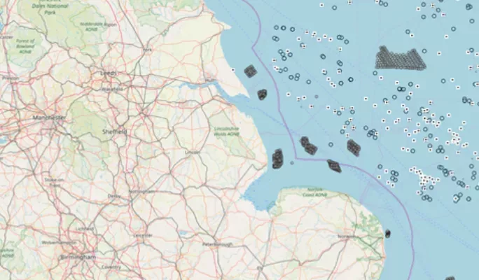
Our ADMIRALTY Marine Data Portal is grounded in the principles of MSDI. Through the portal, users can not only access extensive data on bathymetry, but also the locations of wrecks, obstructions and offshore infrastructure within the UK’s Exclusive Economic Zone – from pipelines to wind turbines. Information on maritime limits, seabed composition and coastlines are also available, along with a range of apps and APIs.
By developing similar data portals, combined with other Professional Services such as training and capability building, we are helping coastal states to improve the accessibility of their own data, without needing their own IT infrastructure or data management capabilities in place.
By making accurate marine geospatial data available to coastal states, they can independently explore ways to improve their economies and resilience to natural disasters, helping them unlock the full potential of their blue economies.
How the UKHO is supporting the blue economy
Our oceans are critical to so many aspects of our day-to-day lives. In the UK alone, they provide jobs for over 500,000 people, contribute more than £47 billion to the economy, and are the means through which 95% of all trade reaches the UK.
At the UKHO, aligned with our role within the UK government, a significant portion of our thinking is dedicated to how we can use marine geospatial data to help promote safe, secure and prosperous oceans – including untapped blue economic opportunities.
Not only will this data help to unlock huge economic potential, but it will also enable us to make the most of our oceans in smarter, more sustainable and more responsible ways.
Read more about how together, with our global partners, we are unlocking a deeper understanding of the world’s oceans, supporting a sustainable and thriving blue economy for the future.

Name
George Huish
George is responsible for developing geospatial data services, with a particular focus on Marine Spatial Data Infrastructure (MSDI) and bringing them to market.