 Skip to main content

All information has been gathered by the UKHO working with NATO, other government agencies and international partners, ensuring that each chart has the most accurate, up to date and verified information available.
Each Maritime Security Chart includes:
- Information about dangers to the security of navigation, including piracy, terrorism, embargoes, mine warfare, exclusion zones, blockades, illegal unreported and unregulated fishing, smuggling and GPS jamming and spoofing. This information, when used in conjunction with official navigational charts, can help towards enhancing the safety of ships, the crew and cargo.
- General security advice, self-protective measures, security procedures and emergency and regional safety contacts, as well as routeing and reporting requirements implemented by the military or regional authorities.
- Regular updates of SRIMs and, when required, new editions of Maritime Security Charts (MSCs) to help maintain the flow of security-related information to enhance situational awareness and general safety.
You can view the Security Related Information to Mariners (SRIM) and coverage for each chart by clicking on the Q chart number or area description below.
|
Chart |
Area |
Scale |
Edition No. / Date |
|---|---|---|---|
|
Chart |
Area Red Sea, Gulf of Aden and Arabian Sea |
Scale 9,000,000 |
Edition No. / Date 10th (05/01/23) |
|
Chart |
Area |
Scale 4,700,000 |
Edition No. / Date 3rd (25/03/21) |
|
Chart |
Area |
Scale 2,800,000 |
Edition No. / Date 7th (05/01/23) |
|
Chart |
Area |
Scale 7,000,000 |
Edition No. / Date 4th (18/11/21) |
|
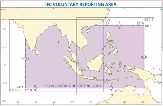
Chart |
Area Singapore to Papua New Guinea |
Scale 7,500,000 |
Edition No. / Date 4th (18/11/21) |
|
Chart |
Area |
Scale 8,500,000 |
Edition No. / Date 3rd (28/02/19) |
Emergency contact details and maritime security points of contact
The regional Emergency Contact authority details are included and highlighted on the MSCs; these are the primary providers of maritime security information to ships transiting areas of perceived risk. These centres also receive reports from shipping transiting Voluntary Reporting Areas (VRA) or those involved in Maritime Security-related incidents and provide the information flow between the Military and the international shipping community. In addition, they deliver a Maritime Security Points of Contact list with recommendations of the authorities and personnel to contact once the emergency call is complete.
Examples are:
United Kingdom Maritime Trade Operations (UKMTO) centre, located in Dubai, is often the primary point of contact for merchant shipping involved in maritime security issues in the Indian Ocean region. The UKMTO operates the VRA as illustrated on UKHO MSC Q6099.
NATO Shipping Centre (NSC) is responsible for Operation Sea Guardian, a maritime security operation in the Mediterranean Sea, the Strait of Gibraltar and approaches (outside the territorial waters of regional nations). NATO encourages commercial shipping entering and transiting this geographical area to join the Mediterranean Voluntary Reporting Scheme (MVRS) as depicted on UKHO MSC Q6110.
Reporting procedures for VRAs
There are several voluntary reporting schemes in operation worldwide and each MSC provides details of the voluntary reporting requirements within the geographical region and includes the reporting formats.
The accompanying instructions give details of when they should be completed and where they should be sent. This covers both the regional reporting centres and any additional reporting requirement from military authorities undertaking protection and assurance to transiting vessels.
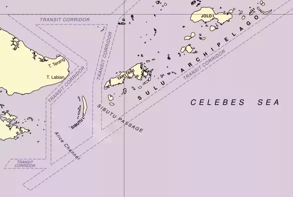
Transit corridors
Maritime Transit Corridors (MTC) have been established in several different geographical areas to enable military assets and regional maritime authorities focus their presence and surveillance efforts.
The Maritime Security Transit Corridor (MSTC) is a military established corridor that includes the Internationally Recommended Transit Corridor as shown on MSC Q6099.
The Transit Corridors in the Sulu Sea and Celebes Sea were established by a trilateral cooperative arrangement between Indonesia, Malaysia and The Philippines. These corridors are designated safety areas and are patrolled by the 3 countries to allow commercial maritime traffic safe passage.
Familiarity and reassurance
The folio of Maritime Security Charts (MSCs) are regularly scrutinised to ensure that they remain as in date as possible. The MSC format is consistent across the products which is now familiar to the maritime community.
The information contained within the MSCs is validated before use to ensure continuity of content which in turn provides reassurance to the mariner.